
Daylight chart
A whole year of daylight, twilight and night for your town — drawn as one printable chart.

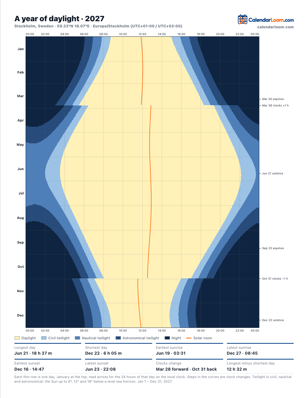
A table of sunrise times tells you about one day. This chart shows the whole year at once: how fast the evenings draw in, when the mornings finally turn, how long the summer night really stays light. Every town draws a different shape — an hourglass in Stockholm, a barely rippled ribbon in Singapore — and yours is worth having on the wall.
What the chart shows
- Daylight for each of the year’s 365 or 366 days, on the local clock.
- Three twilights — civil, nautical and astronomical — so you can see when it is truly dark.
- Solar noon as a line, wandering against the clock through the year.
- Clock changes, equinoxes and solstices, marked down the side.
- Underneath, the year’s records: longest and shortest day, earliest and latest sunrise and sunset.
The same year in eight cities
Computed for 2026 with the code that draws the chart. Times are on each city’s own clock, daylight saving included — which is why the latest sunrise in New York and Los Angeles falls beside a clock change rather than in midwinter.
| City | Longest day | Shortest day | Difference | Earliest sunset | Latest sunrise |
|---|---|---|---|---|---|
| New York | 15 h 06 m Jun 21 | 9 h 15 m Dec 21 | 5 h 50 m | Dec 7 (16:28) | Oct 31 (07:25) |
| Los Angeles | 14 h 26 m Jun 21 | 9 h 53 m Dec 21 | 4 h 32 m | Dec 4 (16:43) | Mar 8 (07:12) |
| London | 16 h 38 m Jun 21 | 7 h 50 m Dec 21 | 8 h 49 m | Dec 12 (15:51) | Dec 30 (08:06) |
| Berlin | 16 h 50 m Jun 21 | 7 h 39 m Dec 21 | 9 h 11 m | Dec 13 (15:52) | Dec 30 (08:17) |
| Stockholm | 18 h 37 m Jun 21 | 6 h 05 m Dec 21 | 12 h 32 m | Dec 16 (14:47) | Dec 27 (08:45) |
| Tokyo | 14 h 35 m Jun 21 | 9 h 45 m Dec 22 | 4 h 50 m | Dec 5 (16:28) | Jan 7 (06:52) |
| Sydney | 14 h 25 m Dec 22 | 9 h 54 m Jun 21 | 4 h 31 m | Jun 12 (16:53) | Apr 4 (07:09) |
| Singapore | 12 h 12 m Jun 21 | 12 h 03 m Dec 21 | 0 h 09 m | Nov 4 (18:50) | Feb 8 (07:17) |
Stockholm’s day swings by 12 h 32 m between June and December; Singapore’s by 0 h 09 m. That single number is most of what latitude means for daily life.
How it is computed
For every day of the year the chart finds the instants at which the Sun crosses four altitudes — the horizon, and 6°, 12° and 18° below it — using Astronomy Engine, an open-source library tested against NASA’s JPL ephemerides. Searching for the crossings, rather than using the schoolbook sunrise formula, is what keeps the picture right above the Arctic Circle, where on some days there is no sunrise to find. The day is the place’s own calendar day, so a day on which the clocks change is 23 or 25 hours long, exactly as it is lived.
More from the same sky
- Sunrise and sunset calendar, month by month
- Night sky calendar
- The Moon on any date
- All Sun & Moon printables
Questions
How do I read the chart?
Each thin horizontal row is one day, with 1 January at the top and 31 December at the bottom. Across the row run the 24 hours of that day on the local clock, midnight at both edges. The pale band down the middle is daylight; the blue bands beside it are civil, nautical and astronomical twilight; the dark area is night. The width of the pale band is the length of the day, so the shape shows at a glance how the year breathes.
Why is there a sudden step in the curves?
That is the clock change. When daylight saving time starts, every event of the day moves an hour later on the clock overnight, so the whole picture shifts sideways; in autumn it shifts back. Places without daylight saving — most of Asia, Africa and South America — draw smooth curves all year. The dates of the steps are printed beside the chart.
Why is the earliest sunset not on the shortest day?
Because solar noon drifts. The Earth’s orbit is an ellipse and its axis is tilted, so the moment the Sun stands highest moves back and forth against the clock by about half an hour over the year — the orange line on the chart shows it. In December that drift pushes both sunrise and sunset later each day, so the earliest sunset comes before the solstice and the latest sunrise after it. In New York in 2026 the earliest sunset is on Dec 7, the shortest day on Dec 21.
What are the three kinds of twilight?
They are steps of darkness, defined by how far the Sun is below the horizon. Civil twilight (down to 6°): bright enough to be outside without lamps. Nautical twilight (6° to 12°): the horizon at sea is still visible and the brighter stars are out. Astronomical twilight (12° to 18°): the sky looks dark, but faint objects are still washed out. Below 18° it is fully night. In summer at high latitudes the Sun never gets that far down, and the chart shows that the night never becomes fully dark.
Can I print it as a poster?
The PDF is a Letter or A4 page rendered at about 288 dots per inch, sharp at its own size. A print shop can enlarge it for a wall, where it is read from further away anyway. An ink-saving palette in greys is included for laser printers.
Is my location sent anywhere?
Only the town name you type is sent, to a place-search service, so that it can be found. The 365 days of Sun positions are calculated in your own browser, and the PDF is built there too.